Staypoint detection with GeoLife
A compact, reproducible comparison of staypoint detection with fastmob and GeoPandas-oriented trackintel. We use the same trajectory, thresholds, and output checks for both implementations.
[2K [90m━━━━━━━━━━━━━━━━━━━━━━━━━━━━━━━━━━━━━━━━[0m [32m21.7/21.7 MB[0m [31m38.8 MB/s[0m eta [36m0:00:00[0m
[2K [90m━━━━━━━━━━━━━━━━━━━━━━━━━━━━━━━━━━━━━━━━[0m [32m156.5/156.5 kB[0m [31m8.6 MB/s[0m eta [36m0:00:00[0m
[2K [90m━━━━━━━━━━━━━━━━━━━━━━━━━━━━━━━━━━━━━━━━[0m [32m96.5/96.5 kB[0m [31m3.9 MB/s[0m eta [36m0:00:00[0m
[2K [90m━━━━━━━━━━━━━━━━━━━━━━━━━━━━━━━━━━━━━━━━[0m [32m104.7/104.7 kB[0m [31m6.6 MB/s[0m eta [36m0:00:00[0m
[?25h
1. Load a real trajectory dataset
GeoLife contains timestamped GPS fixes for multiple users. The download is large, so the next cells keep the example focused on a deterministic slice.
!wget -O geolife.zip "https://download.microsoft.com/download/F/4/8/F4894AA5-FDBC-481E-9285-D5F8C4C4F039/Geolife%20Trajectories%201.3.zip"
!unzip -q geolife.zip -d geolife
--2026-09-09 12:14:27--  https://download.microsoft.com/download/F/4/8/F4894AA5-FDBC-481E-9285-D5F8C4C4F039/Geolife%20Trajectories%201.3.zip
Resolving download.microsoft.com (download.microsoft.com)... 23.14.142.52, 2600:1407:3c00:e9b::317f, 2600:1407:3c00:ea3::317f
Connecting to download.microsoft.com (download.microsoft.com)|23.14.142.52|:443... connected.
HTTP request sent, awaiting response... 200 OK
Length: 313164406 (299M) [application/octet-stream]
Saving to: ‘geolife.zip’

geolife.zip         100%[===================>] 298.66M  67.3MB/s    in 4.3s

2026-09-09 12:14:32 (69.7 MB/s) - ‘geolife.zip’ saved [313164406/313164406]
2. Import the tools
fastmob accepts ordinary dataframe columns. We normalize timestamps to UTC before running the detector.
import geopandas as gpd
import matplotlib.pyplot as plt
import pandas as pd
import trackintel as ti
import fastmob
import seaborn as sns
3. Set the detection contract
A staypoint is a stop lasting at least minutes inside a radius_m radius. gap_minutes separates observations when a device stops reporting.
4. Prepare the trajectory
fastmob accepts ordinary dataframe columns. We normalize timestamps to UTC before running the detector.
tdf = fastmob.io.load_geolife_trajectories("/content/geolife/Geolife Trajectories 1.3").to_pandas()[:10_000_000]

tdf
| uid | lat | lng | datetime | |
|---|---|---|---|---|
| 0 | 000 | 39.984702 | 116.318417 | 2008-10-23 02:53:04 |
| 1 | 000 | 39.984683 | 116.318450 | 2008-10-23 02:53:10 |
| 2 | 000 | 39.984686 | 116.318417 | 2008-10-23 02:53:15 |
| 3 | 000 | 39.984688 | 116.318385 | 2008-10-23 02:53:20 |
| 4 | 000 | 39.984655 | 116.318263 | 2008-10-23 02:53:25 |
| ... | ... | ... | ... | ... |
| 9999995 | 041 | 39.946090 | 116.207897 | 2009-06-05 09:42:59 |
| 9999996 | 041 | 39.945933 | 116.207798 | 2009-06-05 09:43:00 |
| 9999997 | 041 | 39.945780 | 116.207702 | 2009-06-05 09:43:01 |
| 9999998 | 041 | 39.945627 | 116.207605 | 2009-06-05 09:43:02 |
| 9999999 | 041 | 39.945477 | 116.207508 | 2009-06-05 09:43:03 |
10000000 rows × 4 columns
<class 'pandas.core.frame.DataFrame'>
RangeIndex: 10000000 entries, 0 to 9999999
Data columns (total 4 columns):
# Column Dtype
--- ------ -----
0 uid object
1 lat float64
2 lng float64
3 datetime datetime64[us, UTC]
dtypes: datetime64[us, UTC](1), float64(2), object(1)
memory usage: 305.2+ MB
5. Benchmark fastmob
This timed cell measures the complete staypoint operation. Repeat it after changing the slice or thresholds; the first run may include warm-up costs.
%%timeit

fastmob_result = fastmob.stay_locations(
    tdf,
    minutes_for_a_stop=minutes,
    spatial_radius_km=radius_m / 1000,
    no_data_for_minutes=gap_minutes,
    leaving_time=True,
)
del fastmob_result # Save system RAM
2.15 s ± 439 ms per loop (mean ± std. dev. of 7 runs, 1 loop each)
6. Build the GeoPandas-style baseline
trackintel works with a Positionfixes GeoDataFrame, so we create point geometry from the same latitude and longitude columns.
df = tdf.rename(columns={"uid": "user_id", "datetime": "tracked_at"})

gdf = gpd.GeoDataFrame(
  df,
  geometry=gpd.points_from_xy(df["lng"], df["lat"]),
  crs="EPSG:4326"
)

pfs = ti.Positionfixes(gdf)

del df, gdf
7. Benchmark the GeoPandas-style baseline
This uses trackintel's sliding-window detector with equivalent distance, time, gap, and trailing-stop settings.
%%timeit

_, trackintel_result = pfs.generate_staypoints(
    method='sliding', dist_threshold=radius_m, time_threshold=minutes,
    gap_threshold=gap_minutes, include_last=True, n_jobs=-1,
)
del trackintel_result # Save System RAM
/usr/local/lib/python3.13/dist-packages/trackintel/preprocessing/positionfixes.py:112: UserWarning: 1912 duplicates were dropped from your positionfixes. Dropping duplicates is recommended but can be prevented using the 'exclude_duplicate_pfs' flag.
  warnings.warn(warn_str)
/usr/local/lib/python3.13/dist-packages/trackintel/preprocessing/positionfixes.py:112: UserWarning: 1912 duplicates were dropped from your positionfixes. Dropping duplicates is recommended but can be prevented using the 'exclude_duplicate_pfs' flag.
  warnings.warn(warn_str)
/usr/local/lib/python3.13/dist-packages/trackintel/preprocessing/positionfixes.py:112: UserWarning: 1912 duplicates were dropped from your positionfixes. Dropping duplicates is recommended but can be prevented using the 'exclude_duplicate_pfs' flag.
  warnings.warn(warn_str)
/usr/local/lib/python3.13/dist-packages/trackintel/preprocessing/positionfixes.py:112: UserWarning: 1912 duplicates were dropped from your positionfixes. Dropping duplicates is recommended but can be prevented using the 'exclude_duplicate_pfs' flag.
  warnings.warn(warn_str)
/usr/local/lib/python3.13/dist-packages/trackintel/preprocessing/positionfixes.py:112: UserWarning: 1912 duplicates were dropped from your positionfixes. Dropping duplicates is recommended but can be prevented using the 'exclude_duplicate_pfs' flag.
  warnings.warn(warn_str)
/usr/local/lib/python3.13/dist-packages/trackintel/preprocessing/positionfixes.py:112: UserWarning: 1912 duplicates were dropped from your positionfixes. Dropping duplicates is recommended but can be prevented using the 'exclude_duplicate_pfs' flag.
  warnings.warn(warn_str)
/usr/local/lib/python3.13/dist-packages/trackintel/preprocessing/positionfixes.py:112: UserWarning: 1912 duplicates were dropped from your positionfixes. Dropping duplicates is recommended but can be prevented using the 'exclude_duplicate_pfs' flag.
  warnings.warn(warn_str)
/usr/local/lib/python3.13/dist-packages/trackintel/preprocessing/positionfixes.py:112: UserWarning: 1912 duplicates were dropped from your positionfixes. Dropping duplicates is recommended but can be prevented using the 'exclude_duplicate_pfs' flag.
  warnings.warn(warn_str)


2min 50s ± 4.65 s per loop (mean ± std. dev. of 7 runs, 1 loop each)
8. Compare the detected stops
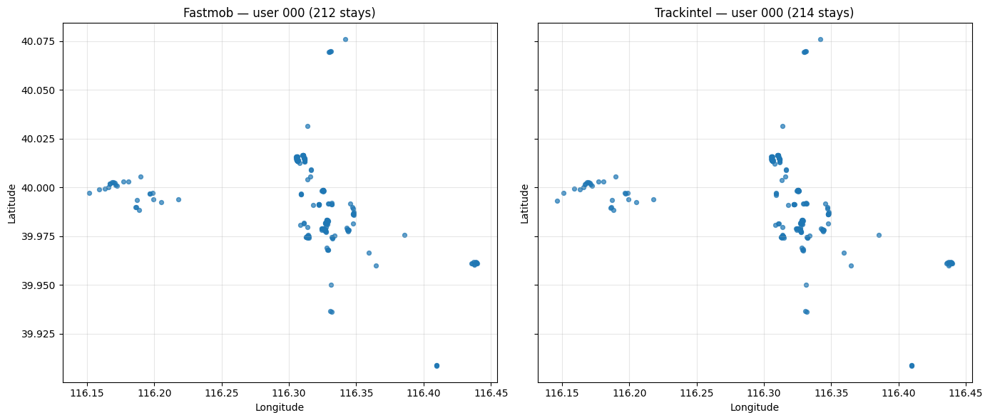
The plot below shows one user's staypoints from both methods. Similar locations indicate comparable detection behavior; differences usually come from implementation details or edge handling.
fastmob_result = fastmob.stay_locations(
    tdf,
    minutes_for_a_stop=minutes,
    spatial_radius_km=radius_m / 1000,
    no_data_for_minutes=gap_minutes,
    leaving_time=True,
)

del tdf
trackintel_result = pfs.generate_staypoints(
    method='sliding', dist_threshold=radius_m, time_threshold=minutes,
    gap_threshold=gap_minutes, include_last=True, n_jobs=-1,
)

del pfs
/usr/local/lib/python3.13/dist-packages/trackintel/preprocessing/positionfixes.py:112: UserWarning: 1912 duplicates were dropped from your positionfixes. Dropping duplicates is recommended but can be prevented using the 'exclude_duplicate_pfs' flag.
  warnings.warn(warn_str)
user_id = "001"

fm_full = fastmob_result
fm = fm_full[fm_full["uid"].astype(str).str.zfill(3) == user_id]

ti_full = trackintel_result[1]
ti_stays = ti_full[ti_full["user_id"].astype(str).str.zfill(3) == user_id]

fig, axes = plt.subplots(1, 2, figsize=(14, 6), sharex=True, sharey=True)

axes[0].scatter(fm["lng"], fm["lat"], s=18, alpha=0.7)
axes[0].set_title(f"Fastmob — user 000 ({len(fm)} stays)")

axes[1].scatter(ti_stays.geometry.x, ti_stays.geometry.y, s=18, alpha=0.7)
axes[1].set_title(f"Trackintel — user 000 ({len(ti_stays)} stays)")

for ax in axes:
    ax.set_xlabel("Longitude")
    ax.set_ylabel("Latitude")
    ax.grid(alpha=0.3)

plt.tight_layout()
plt.show()